
One thing that the Hamilton County Parks in Ohio does extremely well is placing interpretive signs along their trails, and perhaps nowhere is this more important than at Shawnee Lookout Park, given the area’s over 14,000 year history of Native American inhabitation, including the Adena, Hopewell, Shawnee, Miami, Mingo, and Wyandot tribes.
We became interested in going to Shawnee Lookout Park when we saw a social media post mentioning that Bald Eagles were seen scouting out nesting sites. Then, when we reviewed the park’s website and saw information on the Indian Mounds and earthworks Fort, the hook was set.
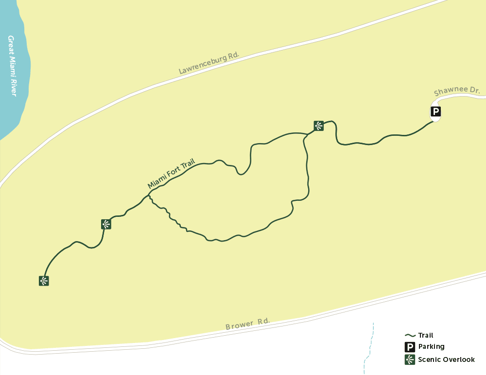
We chose the Miami Fort Trail as it appeared to be more integrated with the Native American history. The trail is well utilized and starts with a steady climb up from the parking area.

The initial flora is primarily of a pioneer plant succession landscape of Redcedars, Hackberry, Black Locust and smaller American Elms. Intermixed, however, were some trophy Black Walnut and an isolated large Linden tree.
Once we crested the hill we were greeted by this sign.

As outlined in the interpretive signs, the “Fort” was a large earthworks, built in approximately 270 A.D. Over time it served many functions, most likely ceremonial and agricultural, but possibly for defense as well. It appears that generally the Native Americans lived in the valley but buried their people in some of the mounds atop the these hills, but past archeological digs have uncovered some evidence of Adena dwellings atop the hill, both inside and outside of the fort.
The entrance into the fort provided this vista. The small mounds bordering the area were man made and the entire structure may have taken several generations to complete.

It is likely that at the time of the Native American peoples there were not this many trees within the fort, as it was used for farming.
From the central fort area the trail leads out along a ridge, giving incomplete views of the Great Miami River Valley and Oxbow wetland below.


Eventually we reached the true overlook of the trail and it was a worthwhile endeavor. Looking out between a Hackberry on the left and a Buckeye on the right we had this view of the confluence of the Great Miami and the Ohio Rivers, both flooded due to our late winter deluge.

Interestingly, this same I-275 bridge was seen in a photo in our blog post about the Oxbow Nature Preserve that is just west of I-275 in Indiana.
https://footpathsblog.com/2021/12/26/the-oxbow-lawrenceberg-in/
A closer view provides more detail.

How is that for an integration of transportation modalities: River, rail, road and air (with CVG up on the hilltop)?
At this point you start your way back to the trailhead on this semi-loop trail and nature, as always, put on an interesting display. First was this sycamore with the dramatic transition zone on its bark.


Then we were treated to these specimens of two of my favorite bird groups, doing a dance around a maple trunk: a White Breasted Nuthatch and female Yellow-Bellied Sapsucker woodpecker.

Their beauty is more notable on these close up photos. As mentioned in previous articles, the nuthatches are one of a few birds that will go down a tree trunk head first.


Soon we were amongst additional remnants of the Native American architecture, with both Indian Mounds and the borrow pits that were the source of dirt for the mounds. It appears the borrow pits now function as ephemeral ponds, providing a habitat for amphibians and insects to lay their eggs and develop their young without the risk of predation by fish.


Again, the interpretive signs did a great job explaining the history of the construction of the earthworks.

We were now headed east with the Ohio River to our right, largely unseen, well down in the valley. The trail became somewhat more challenging with some descending and ascending stairs that traversed a scoliotic course down and up a large ravine.


The final main feature of the trail is a return to the “fort”, which is anchored by this bench that was built in1950 and featured two old millstones, and a monument to Daniel Carter Beard, the founder of the Boy Scouts.


This was on the southern edge of the plateau seen in the earlier “fort” photo.
The semi-loop was completed as we wound our way to exit the earthworks amongst a column of Black Walnuts.

Historical bonus: The photographer was enthralled by these two historic structures that were relocated along the road to the trail head. They are both over 200 years old and were originally located in Elizabethtown, Ohio, down in the valley along the Great Miami River, and within a few miles of Shawnee Lookout.
The log cabin was built in 1795 by Micajah Dunn and was constructed of hand-hewn oak, ash, hickory, and maple.

This Spring House, built in the early 1800’s, originally served two functions: As a spring house on the lower floor, keeping milk and other perishables cool, and as a school on the upper floor. Its preservation was aided by the fact that someone built a large barn structure around it, protecting it from the elements.


In summary, while we did not see the aforementioned Bald Eagles, the Miami Fort Trail at Shawnee Lookout Park did score on three fronts: athletically on fitness due to its rolling terrain, aesthetically through nature, and cognitively through the presentation of Native American history in the region. Now is an ideal time to visit, before the trees leaf out, to enjoy the many views along the ridge top.
Photo credits to Peggy Juengling Burns.
Overview:
Location – In North Bend, Ohio about 21 miles west of downtown Cincinnati.
Parking – Paved lot for 8 to 10 cars.
Facilities – Indoor restroom at the park’s archeological museum.
Trail Conditions – The trail is 1.4 miles long and of moderate difficulty due to terrain change and a series of long steps. The trail is well maintained.
Print Map – https://res.cloudinary.com/govimg/image/upload/v1615483892/5a5f7a6b41a5361ef1395dbc/SL-Miami-Fort-Trail.gif
Benches – One at the formal overlook, about halfway through the hike, and one within the fort itself.
Kids – Kids 4 and over should do well here.
Dogs – Are welcomed while on a leash.
Paired Hikes – Shawnee Lookout Park has several additional trails – Blue Jacket at 1.3 miles, Little Turtle at 2.0 miles, and the Cart Path Trail, which is the repurposed paved golf cart paths from the park’s decommissioned golf course, at approximately 4.5 miles.
Links:
https://www.greatparks.org/parks/shawnee-lookout
Thank you Pat! Are you going to venture out of our area or are there enough trails to keep you here in the area?!!
There are a lot of hiking destinations left within the 2 hour drive region that we consider our home base, but yes soon we will venture more on the road including visiting some National Parks.