
Not every hike is going to be about expansive vistas, seeing endangered species, or majestic trees. Some are just about the exercise, fresh air, mental unwinding, and experiencing nature on a more intimate scale. Cedar Line Nature Preserve in Butler, KY is a great venue for all of these.
Cedar Line is a 43 acre preserve managed by the Pendleton County Fiscal Court. The property was donated to the fiscal court in 2004 by Karen Kuhnhein, before she passed away, wanting it to be used as a nature preserve in perpetuity. She had developed a mini nature center on her land and wanted visitors to be able to explore and experience the beauty of its grounds as she had. Some of her original signs identifying plants are still present.
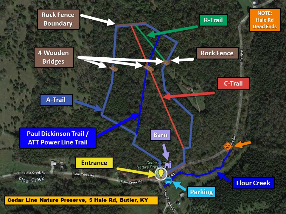
The property features a collection of trails that are well marked and total about 2 miles.

Typical of this part of Kentucky, the trails climb several steep grades but also roll across some ridges. Starting counterclockwise at the barn that is visible from the parking area, the trail meanders through a thicket of Redcedars, and despite it being a sun-drenched south facing slope, the floor is covered by a blanket of moss and soft underfoot.


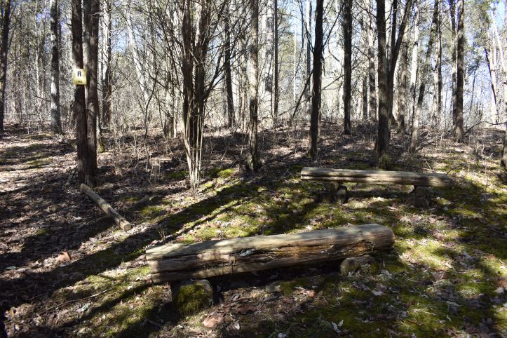
Once up the grade, you are greeted by these appropriately placed split cedar benches, should you need to catch you breath.
Here the trail works its way through a wood that is part cedar, part adolescent white oak and hickory. Due to competition from the developing hardwoods, the cedars are atypically tall and have an open habit.

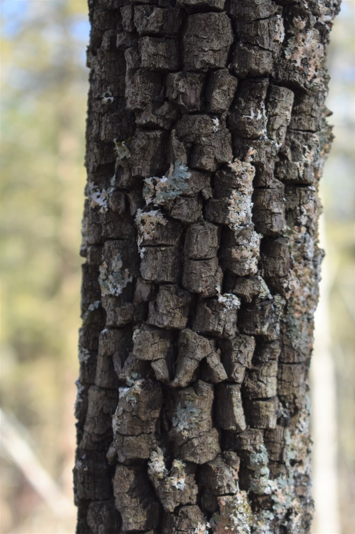
Soon we found ourselves in another seating area, this one with a 360 degree display of lichens, both on the benches themselves, and on the nearby trees. The first noted was on this persimmon tree, characterized by the “alligator skin” blocking of its bark.
The intricacy of these organisms warrants individual photographs.


But my favorite at this locale was this one, that looks to be made of tarnished copper.

One nice feature of the Cedar Line trails are the numerous signs identifying plants, as I think that it adds to the experience of both novices and veterans alike. For me it was this sign.

For decades, whether hiking, golfing, or working on a farm, I have been repeatedly assaulted by an evergreen vine that had round leaves and thorns, and I have always meant to find out more about it. Well here they identified it for me – Greenbrier. In the photo you can see the green vine, with its well spaced thorns, as it works its way up the small tree. It is common throughout the eastern US, and tends to hang out at the same places that I do: Hiking trails, forest edges (read as golf courses), and pine woods. Turns out that much of the plant is edible, especially the new growth, which reportedly tastes like a mild asparagus.
The “A” trail continued to weave through cedar thickets and the oak and hickory deciduous woods. While making photography challenging at times, the low angled winter sunlight allowed for some special effects within the woods.


Along the northern property line we saw a large collection of what appeared to be white pines growing on the neighboring property. But just down the ridge we came upon an isolated pine on the preserve. Due to the surrounding trees it was difficult to get a good photo of the entire tree. On closer examination this specimen was not a white pine. Pine needles always occur in groups, or “fascicles”, and the first step in pine identification is to assess the number of needles in a fascicle. This tree had fascicles of two needles, while white pines have 5 per fascicle, and it also seemed to retain its pine cones as there were none on the floor. That suggests that this is a Virginia Pine.


Shortly, we stumbled on an old friend, something that we do not see too often in Northern Kentucky – Reindeer Lichen (genus Cladonia).

As we were working our way down a hillside, the trail crossed a bridge over a gully and then passed through an old rock wall, seen in the second photo from Trail “C” on a neighboring hillside.


One can only imagine the labor and sweat that went into removing those rocks from a pasture and assembling them into the wall: Now a testament to the land’s long ago use as farm field.
Just before Trail “A” took us back to the parking area, we opted to head uphill on Trail “C”. This trail paralleled a stream bed that was void of running water when we visited, although there was some puddling due to a recent rain. It was on a northeastern facing slope that allowed for some interesting moss and fungal observations. First was this moss specimen growing on the ground, and displaying its reproductive sporophytes, with the spore containing capsules at the top.

And then this fungus, which is every bit as beautiful as a coral.

At the top of the hill, Trail “C” intersects with the Paul Dickison Power Line Trail, which traverses a utility right of way across the preserve, and is sponsored and maintained by the AT&T Pioneers, a community service organization made up of Bell and AT&T employees and retirees.

This was of personal interest to me as my father had a long career with Cincinnati Bell Telephone and has been a long time member of the Pioneers.
The last photo of the hike is of the cedar handrail on the last bridge that we were to cross that day. It was an ecosystem unto itself, featuring mosses and lichens, and again with some late winter sporophyte formation.

The “Keys” to a fun hike –
We were perplexed when we got close to the sign depicting the preserve trails that was shown in the second photo above. We had noted the antique key that was attached but were uncertain of its purpose.

A few days later, as I was writing this article, I pondered whether it was someone’s pun referencing a map “key”. I have since communicated with the Pendleton County Communications Coordinator, Michele Hamilton, who related a story to me. Preserve caretaker and volunteer extraordinaire Barth Johnson, who does a lot of the maintenance and wood working for the facility, had acquired a collection of old keys from his father, after he had passed away. As a tribute to his father, Barth attaches one of the antique keys to structures he builds. Sure enough, when we went back to our photos we found this birdhouse with a mounted key that we had overlooked.

This kind of seek and find can add to the adventure of the hike for the young, and those that are young at heart. The photographer is already looking forward to a return visit in search of other keys.
In summary, Cedar Line Nature Preserve demonstrates that even small venues have a lot to offer when one is in search of an outdoor experience. I had no anticipation of the beauty that we would see here, and appreciate that much of it was on the miniature scale. Somehow nature has opted to integrate itself with Karen Kuhnhein’s vision, bringing these intricate organisms like moss, lichen and fungi in close proximity to the transient visitor. When this hike was over we felt the hill climb experience in our thighs and our calves, but we measured the beauty of the place in our peace of mind as we drove away, and now, as we reflect back through these photos of the outing.
Photo credits to Peggy Juengling Burns.
Overview:
Location – Just outside Butler, KY, about 29 miles south of downtown Cincinnati.
Parking – Nice gravel lot for about 5 to 6 cars.
Facilities – None.
Trail Conditions – Moderate due to terrain. The trails are smooth and well maintained. On the day of our hike there were a few downed trees across the path due to the recent ice storm, and I’m happy to report that Pendleton County, after being notified, has already addressed them. This preserve is clearly valued by the county leadership and their trail volunteers.
Print Map Link – https://pendletoncounty.ky.gov/Documents/Map%20of%20CedarLine.jpg
Benches – Numerous
Kids – Kids 4 and over should do well here with minimal assistance.
Dogs –Welcomed while on a leash.
Paired Hikes – none noted at this time.
Links:
https://pendletoncounty.ky.gov/Pages/CedarLineNaturePreserve.aspx